Alternative Routes
The City of Tampa is currently in the process of evaluating all possible preliminary route alternatives for the Harbour Island Force Main Replacement Design-Build Project. Presented below in no particular order, are the 13 route alternatives, including two, which were provided by the Community Task Force.
Each route has received a preliminary evaluation. To see the evaluations and recommended routes for additional study, please click here. If you have any questions or concerns related to any of the routes, please click on the “Contact Us” tab and fill out the form.
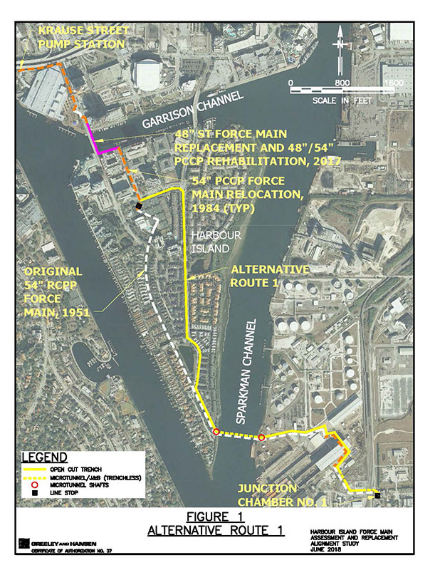
Alternative Route 1
Beginning at the connection point to the existing force main at the intersection of Knights Run Avenue and Harbour Place Drive, alternative route 1 heads easterly in Knights Run Drive to Beneficial Drive; thence southerly in Beneficial Drive to a roundabout intersection with Renaissance Way. At this point the route departs the roadway corridor and heads southerly parallel to the route of the existing force main, which lies within an existing 20-foot wide easement, to the edge of Sparkman Channel; thence departing Harbour Island the route turns easterly in a tunnel across and beneath Sparkman Channel to Hooker’s Point which is managed by Port Tampa Bay. On Hookers Point the route generally follows the route of the existing force main to Junction Chamber No. 1 at the Howard F. Curren Advanced Wastewater Treatment Plant.
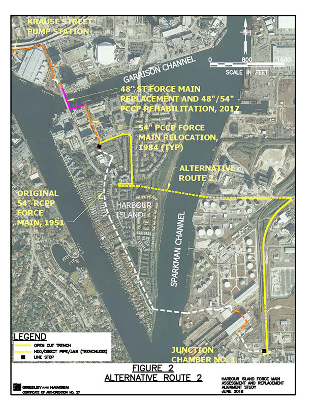
Alternative Route 2
Beginning at the connection point to the existing force main at the intersection of Knights Run Avenue and Harbour Place Drive, alternative route 2 heads easterly in Knights Run Drive to Beneficial Drive; thence southerly in Beneficial Drive to the intersection with Harbour Island Boulevard; thence westerly in Harbour Island Boulevard to a stopping point located just east of the intersection with Harbour Bay Drive. Here the route makes a “U-turn” into a tunnel heading easterly beneath the following features respectively: Beneficial Drive, a retention pond, a mangrove tree corridor, Sparkman Channel, and the seawall on the east side of Sparkman Channel. On Hooker’s Point, managed by Port Tampa Bay, the route emerges from the tunnel and continuous easterly parallel to a property boundary and a driveway toward and beneath a railroad right-of-way to Maritime Boulevard where the route turns southwesterly and follows Maritime Boulevard to the treatment plant.
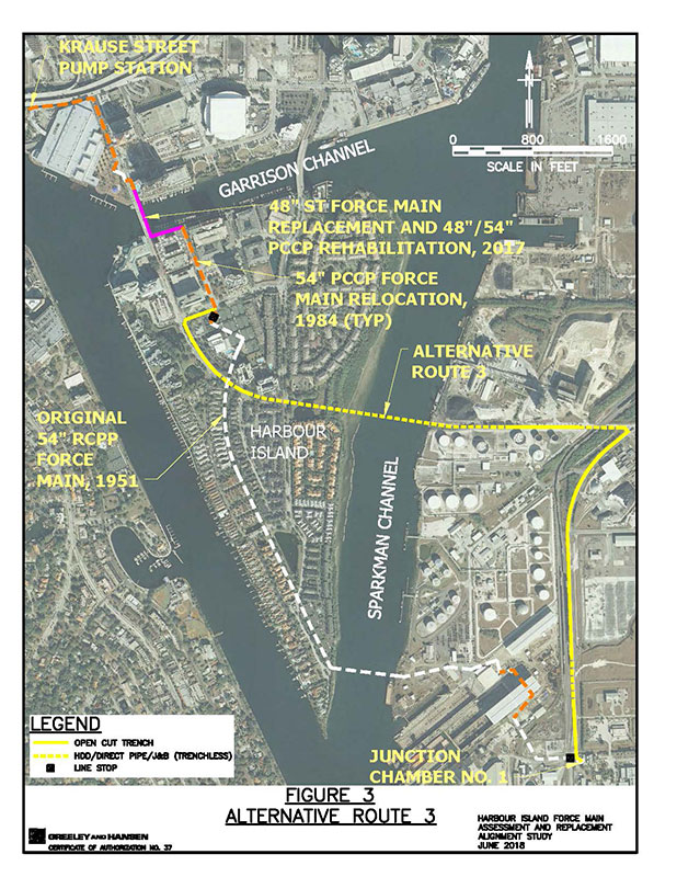
Alternative Route 3
Beginning at the connection point to the existing force main at the intersection of Knights Run Avenue and Harbour Place Drive, alternative route 3 heads westerly in Knights Run Drive to Harbour Island Boulevard thence southerly and then southeasterly in Harbour Island Boulevard to a point just past the intersection with Harbour Bay Drive. Here the route enters a tunnel heading easterly beneath the following features respectively: Beneficial Drive, a retention pond, a mangrove tree corridor, Sparkman Channel, and the seawall on the east side of Sparkman Channel. On Hooker’s Point, managed by Port Tampa Bay, the route emerges from the tunnel and continuous easterly parallel to a property boundary and a driveway toward and beneath a railroad right-of-way to Maritime Boulevard where the route turns southwesterly and follows Maritime Boulevard to the treatment plant.
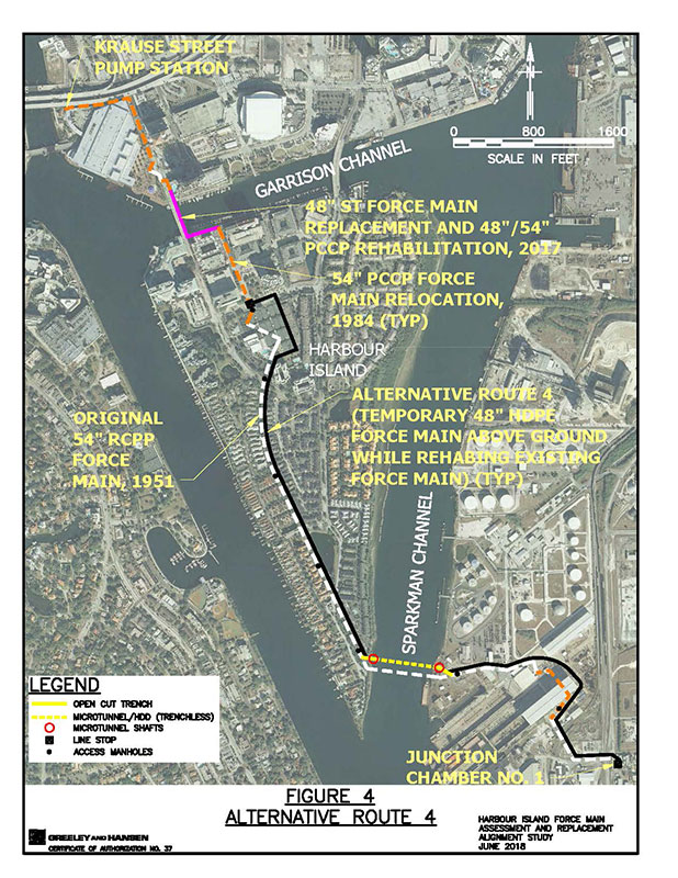
Alternative Route 4
This alternative comprises rehabilitation of the existing force main. This requires that the flow in the existing force main be diverted into a new temporary bypass force main lying mostly on top of the ground except where it crosses roadways where it can be buried to minimize public disruption. The temporary bypass would begin at the connection point to the existing force main at the intersection of Knights Run Avenue and Harbour Place Drive, the temporary bypass route heads easterly in Knights Run Drive to the west boundary of the tennis courts; thence southerly along the west boundary of the tennis courts to the southern boundary of the tennis courts; thence westerly to its intersection with the existing force main easement corridor. Thence turning southerly parallel to the existing force main easement corridor along the west boundary of the parking lot for Harbour Court Condominiums to and beneath Harbour Island Boulevard; thence continuing southerly in a mostly grassed easement corridor to its intersection with Harbour Passage Way. Here the temporary bypass force main would be buried beneath Harbour Passage Way and continue southerly in a mostly grassed easement corridor to South Beneficial Drive. Here the bypass would pass beneath South Beneficial Drive and continue southerly in a mostly grassed easement corridor to a point just short of the edge of Sparkman Channel where the temporary bypass would reconnect to either the existing force main or a new force main constructed across Sparkman Channel.
When the flow is diverted into the new temporary bypass force main, rehabilitation of the existing force main can proceed by constructing access points or manways at approximate 1,000-foot intervals where access is feasible. These access points or manways would be used to ventilate the pipeline, allow workers access inside the pipe and insertion of rehabilitation materials. The method of rehabilitation is not designed at this time but will likely comprise either a reinforced coating system similar to fiberglass or an inserted liner pipe that is inert to corrosion.
A similar temporary bypass force main would be constructed on the Hooker’s Point portion of this alternative and similar rehabilitation could proceed.
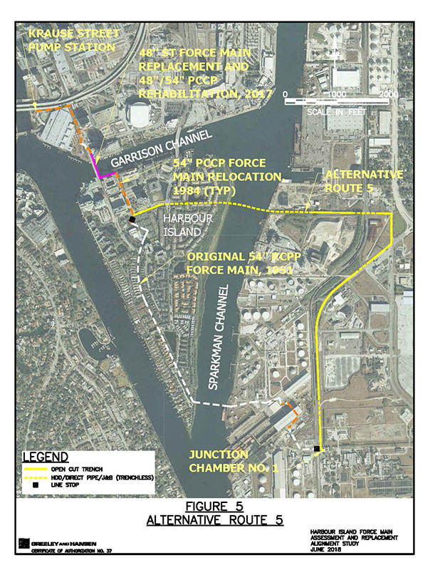
Alternative Route 5
Beginning at the connection point to the existing force main at the intersection of Knights Run Avenue and Harbour Place Drive, alternative route 5 heads easterly in Knights Run Drive to point just short of Beneficial drive where the route enters a tunnel heading easterly along Knights Run Avenue beneath Beneficial Drive, beneath and parallel to the south boundary of a landscaped pond, thence beneath and squeezing below a narrow gap between Island Place Condominium buildings to and beneath Sparkman Channel where the route continues easterly to Hooker’s Point where the tunnel terminates. Here the route continues easterly parallel to a CSX right-of-way boundary to 20th Street; thence southerly in 20th Street to Maritime Boulevard; thence southwesterly and then southerly in Maritime Boulevard to the treatment plant.
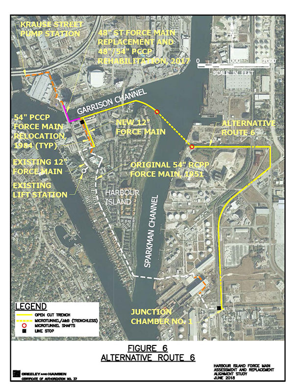
Alternative Route 6
Beginning at the connection point to the existing force main at the intersection of Harbour Place Drive and Garrison Channel, alternative route 6 heads easterly in Garrison Channel to and beneath the Beneficial Drive Bridge, continuing easterly then southeasterly to a point where the route enters a tunnel near the shoreline of Harbour Island heading southeasterly to a point on Hookers Point where the tunnel terminates and the route turns easterly parallel to a CSX right-of-way boundary to 20th Street; thence southerly in 20th Street to Maritime Boulevard; thence southwesterly and then southerly in Maritime Boulevard to the treatment plant.It should be noted that the wastewater collected on Harbour Island is pumped into a 12-inch force main that connects to the existing 54-inch force main at the intersection of Knights Run Avenue and Harbour Place Drive. Since alternative route 6 would decommission the 54-inch force main located here, the 12-inch force main would have to be extended north in Harbour Place Drive to Garrison Channel where it could be connected to the proposed force main.
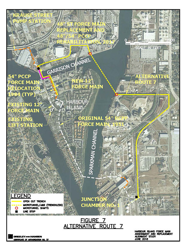
Alternative Route 7
Beginning at the connection point to the existing force main at the intersection of Franklin Street and Old Water Street, alternative route 7 heads easterly in Old Water Street past Amalie Arena thence turning northerly still in Old Water Street to the intersection with Channelside Drive; thence easterly in Channelside Drive across Beneficial Drive to a point where the route turns southerly parallel to the west property boundary of a parcel of property owned by Port Tampa Bay and occupied by the Starship Dinner Cruises until just before the route reaches Garrison Channel where it enters a tunnel beneath Garrison Channel heading southeasterly to a point on Hookers Point where the tunnel terminates and the route turns easterly parallel to a CSX right-of-way boundary to 20th Street; thence southerly in 20th Street to Maritime Boulevard; thence southwesterly and then southerly in Maritime Boulevard to the treatment plant.
The existing 12-inch force main (see alt. route 6, 2nd paragraph) would have to be extended from the intersection of Knights Run Avenue and Harbour Place Drive north in Harbour Island Place to Garrison Channel where the route turns west in Garrison Channel toward the Harbour Island Bridge, thence turning north across the bridge to Old Water Street where it could be connected to the proposed force main.
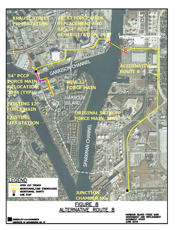
Alternative Route 8
Beginning at the connection point to the existing force main at the intersection of Franklin Street and Old Water Street, alternative route 8 heads easterly in Old Water Street past Amalie Arena thence turning northerly still in Old Water Street to the intersection with Channelside Drive; thence easterly in Channelside Drive across Beneficial Drive past the Florida Aquarium to a roundabout intersection where the route turns easterly parallel to the north property boundary of the Florida Aquarium parcel to just before Sparkman Channel where the route enters a tunnel. Heading southeasterly in a tunnel beneath the channel, the tunnel terminates on Hookers Point then turns easterly in Grant Street to 20th Street; thence southerly in 20th Street to Maritime Boulevard; thence southwesterly then southerly in Maritime Boulevard to the treatment plant.
The existing 12-inch force main (see alt. route 6, 2nd paragraph) would have to be extended from the intersection of Knights Run Avenue and Harbour Place Drive north in Harbour Island Place to Garrison Channel where the route turns west in Garrison Channel toward the Harbour Island Bridge, thence turning north across the bridge to Old Water Street where it could be connected to the proposed force main.
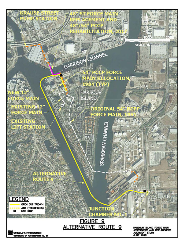
Alternative Route 9
Beginning at the connection point to the existing force main at the south end of the Harbour Island Boulevard bridge over Garrison Channel, alternative route 9 heads west in Garrison Channel thence around Jackson’s Bistro where the route enters the portion of the Hillsborough River known as Seddon Channel, thence southerly in Seddon Channel past the southern-most point of Harbour Island thence turning southwesterly across Sparkman Channel to Shoreline Avenue on Hookers Point; thence northeasterly then easterly in Shoreline Avenue across Maritime Boulevard to the treatment plant.
The existing 12-inch force main (see alt. route 6, 2nd paragraph) would have to be extended from the intersection of Knights Run Avenue and Harbour Place Drive north in Harbour Island Place to just before Garrison Channel where the route turns west and parallel to the south boundary of Garrison Channel to the southern end of the Harbour Island Bridge where it could be connected to the proposed force main.
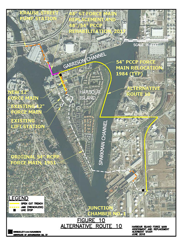
Alternative Route 10
Beginning at the connection point to the existing force main at the intersection of Harbour Place Drive and Garrison Channel, alternative route 10 heads easterly in Garrison Channel to and beneath the Beneficial Drive Bridge, continuing easterly to a point where the route curves to the southeast parallel to the shoreline of Harbour Island and eventually heading southerly in Sparkman Channel parallel to the shoreline of Harbour Island to a point where the route turns easterly beneath Sparkman Channel and across the seawall on the east side of Sparkman Channel. On Hooker’s Point the route continuous easterly parallel to a property boundary and a driveway toward and beneath a railroad right-of-way to Maritime Boulevard where the route turns southwesterly and follows Maritime Boulevard to the treatment plant.
The existing 12-inch force main (see alt. route 6, 2nd paragraph) would have to be extended from the intersection of Knights Run Avenue and Harbour Place Drive north in Harbour Island Place to just before Garrison Channel where it could be connected to the proposed force main.
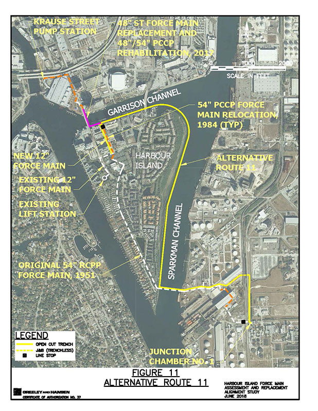
Alternative Route 11
Beginning at the connection point to the existing force main at the intersection of Harbour Place Drive and Garrison Channel, alternative route 11 heads easterly in Garrison Channel to and beneath the Beneficial Drive Bridge, continuing easterly to a point where the route curves to the southeast parallel to the shoreline of Harbour Island and eventually heading southerly in Sparkman Channel parallel to the shoreline of Harbour Island to a point where the route intersects the route of the existing force main at the Sparkman Channel Crossing. Here the route turns easterly, parallel to the existing force main, beneath Sparkman Channel and across the seawall on the east side of Sparkman Channel to Hookers Point. On Hookers Point the route generally follows the route of the existing force main to the treatment plant.
The existing 12-inch force main (see alt. route 6, 2nd paragraph) would have to be extended from the intersection of Knights Run Avenue and Harbour Place Drive north in Harbour Island Place to just before Garrison Channel where it could be connected to the proposed force main.
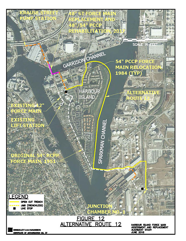
Alternative Route 12
Beginning at the connection point to the existing force main at the intersection of Knights Run Avenue and Harbour Place Drive, alternative route 12 heads easterly in Knights Run Drive to Beneficial Drive; thence northerly in Beneficial Drive to Garrison Channel thence heading easterly in Garrison Channel to a point where the route curves to the southeast parallel to the shoreline of Harbour Island and eventually heading southerly in Sparkman Channel parallel to the shoreline of Harbour Island to a point where the route intersects the route of the existing force main at the Sparkman Channel Crossing. Here the route turns easterly, parallel to the existing force main, beneath Sparkman Channel and across the seawall on the east side of Sparkman Channel to Hookers Point. On Hookers Point the route generally follows the route of the existing force main to the treatment plant.
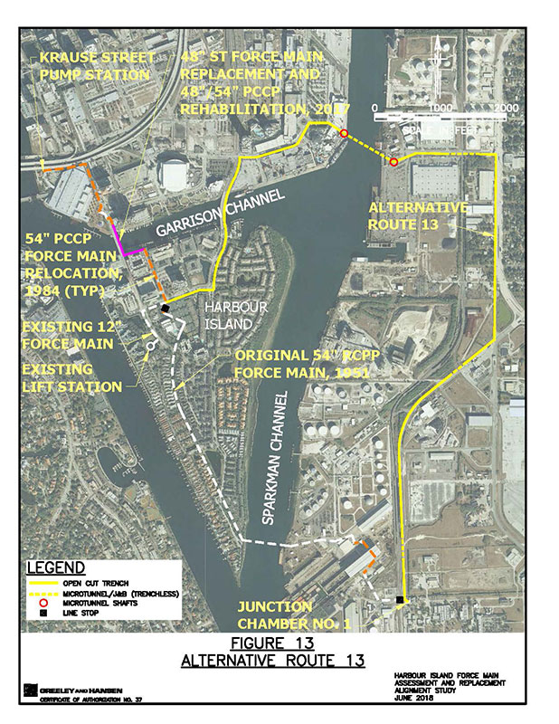
Alternative Route 13
Beginning at the connection point to the existing force main at the intersection of Knights Run Avenue and Harbour Place Drive, alternative route 13 heads easterly in Knights Run Drive to Beneficial Drive; thence northerly in Beneficial Drive across Garrison Channel to the intersection with Channelside Drive; thence easterly in Channelside Drive past the Florida Aquarium to a roundabout intersection where the route turns easterly parallel to the north property boundary of the Florida Aquarium parcel to just before Sparkman Channel where the route enters a tunnel. Heading southeasterly in a tunnel beneath the channel, the tunnel terminates on Hookers Point then turns easterly in Grant Street to 20th Street; thence southerly in 20th Street to Maritime Boulevard; thence southwesterly then southerly in Maritime Boulevard to the treatment plant.


